29 April 2009

Worland, WY, part 1

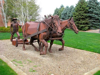
Worland is just a half hour drive north of Thermopolis and is the county seat for Washakie County. Below are pictures of Pioneer Square and the county court house.


The sign below reads:
Dedicated to those who came first
COUNTY OF WASHAKIE
Sheltered by formidable mountains,
the Big Horn Basin for ten thousand Great Suns
nurtured hunting tribes of Crow and Sioux, Arapahoe and Shoshone
following Pte Tanka, the Buffalo, their livelihood
Trappers and gold seekers ripped and ran
Bluecoats came and went
Ranchers and farmers brought courageous wives to put down roots
to weave a new civilization here in the wilderness
They built sand and sage and water into Worland and Washakie
We honor these first families who fulfilled Isaiah's prophesy
...and the desert shall rejoice
and blossom as the rose


The steel sculptures below were created by Lyndon Fayne Pomeroy in 1989. Click here for a picture of the artist and a short biography and here for a newspaper article on him.


Across the street from Pioneer Square (see photo above) is the court house. Click here for a satellite image, and look for the northwest and northeast corners of 10th Street and Big Horn Avenue.


Below is a sculpture of Chief Washakie of the Shoshone Indians.


As the plaque says below, Peter Toth is the sculptor.

The artwork below is on the building housing the restrooms in Pioneer Square.

See also Worland, WY, part 2.

27 April 2009

Boysen Reservoir, part 1

Crossing over to the west side of Boysen Dam is the view below. We decided to park the car and hike up the road to see if we could find a way to the summit.


From the road above we enjoyed this view below.

The road switches back and up the mountain. Here is a satellite view of the road.


Above is the view of Boysen Dam from the crest of the road (below).

The rest of the climb was a little steep but certainly manageable.

Below is the view looking southeast.

The road south to Shoshoni is on the far left of the shot below.

Here is another look at the road to Shoshoni with a zoom lens:

Below is the view looking north toward Wind River Canyon.

Here is the view from the summit looking west:

On the way back down, I took the shot below of the ridge we walked along to take the pictures above.


Here is another view of the road where it switches back.


This is the road across the dam.

These are some of the flowers we saw along the way during our hike.


See also Boysen Reservoir, part 4, part 3, part 2.
See also Wind River Canyon, part 5, part 4, part 3, part 2, part 1.

25 April 2009

Mutt's daffodils

Part of the fun of taking pictures in Thermopolis is the people I meet. Today I had a long conversation with Mutt in front of his home (below). Yes, he told me that's what everyone calls him.

Mutt is 85 and still going strong. He is especially proud of the daffodils his wife planted before she died six years ago. He also showed me pictures of the deer which come to his back door and feed from his hand.


See also flowers, etc., part 12, part 11, part 10, part 9, part 8, part 7, part 6, part 5, part 4, part 3, part 2, part 1.

For more flowers (in the reverse order they were taken), see also Big Horn Mountains, part 2; Castle Gardens near Ten Sleep (second half); Highway US-20, part 2; Big Horn Mountains, part 1; Hot Springs State Park: trees and flowers, part 2, part 1; Crosby, WY (second half); Wind River Canyon, part 5; Hot Springs State Park: Flower Gardens.

See also trees and bushes, part 6, part 5, part 4, part 3, part 2, part 1.
See also autumn colors, part 9, part 8, part 7, part 6, part 5, part 4, part 3, part 2, part 1.

24 April 2009

T-Hill hike, part 4

The cross in the photograph below is barely visible from a distance, but occasionally my wife and I can make it out when we are enjoying the Bath House. So we decided today to hike up T-Hill and get a closer look.


I took this shot of the Hot Springs terraces (below) with my telephoto lens from the above location.

We could have taken the road, but we thought it would be far more interesting to climb up the hill by following the fence which restricts the buffalo. It does get a bit steep at the top, but you can always steady yourself with the fence.


Below is the view of Monument Hill.


When we reached the end of the fence (above), it was clear to us that we needed to find another way to the summit without climbing the rocks. So we used the path pictured below.

Below is another shot of what it looks like when you reach the end of the fence.

Then we climbed this path to the top:

The fence continues at the edge of the cliff and runs around the perimeter of the summit.
Instead of taking the road down, we found one of the paths made by the buffalo and followed that.


Below is another telephoto shot of the cross with the Star Plunge in the background. The small building just to the right of the cross is where the water is cooled before being sent to other locations within the State Park.


Here are some yellow wildflowers next to buffalo droppings:

These small wildflowers are next to the road:

And finally we got back to the entrance of T-Hill, next to US-20. The sign to the left of the gate says, "WARNING BISON ARE DANGEROUS".

See also T-Hill hike, part 3, part 2, part 1.