At the north end of Springview Street is an outdoor learning center. Officially, you need to get a "permission card" to view this area, and this can be acquired from the University of Wyoming/Hot Springs County Cooperative Extension Service located at 328 Arapahoe, just behind the library.
The gate is always locked, so just use the path around the large post on the far right.
 The sign below informs the visitors that "the purpose" of this outdoor learning center "is to enhance mankind's knowledge of the past, present & future knowledge of: Plant Species, Soils, Geology, Wild Life..., The Eco-System..."


 The sign on the right (below) is entitled, The Hot Springs. It reads, "Most of the water for the Hot Spring originates from an underground flow from the Owl Creek Mountains, west of this location. Precipitation in the form of rainfall enters the porous rock layers of the Owl Creek Mountains and eventually flows downward through various underground formations to the Hot Springs. The heat and chemicals in the water are derived from rock and subterranean volcanic gases of the earth." There is a diagram to go along with this.
 The sign below reads, "THE SPILLER-KING BUTTE area is home to many wildlife species, including mule deer, chukar partridge and an occasional mountain lion. Many small animals and birds also occupy the site. Due top the excellent habitat conditions and protection from excessive human disturbance, this area is able to sustain diverse and abundant wildlife even though it is adjacent to the town of Thermopolis. The location provides an ideal outdoor classroom, and students from elementary grades through graduate programs visit the site."
 Below is a close-up of the above shot. It is part of the west side of T-Hill.
 To climb the butte, pictured in the first two shots, you must walk to the back side of it (the north side) by following the road below.
 The road above leads to this road.
 Climbing to the top and looking north, you can see the airport runway on the left.
 Then walk to the southern end of the butte so that you can see the city of Thermopolis.
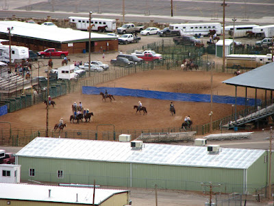
 Below is a close-up of the county fair grounds.
 The dome below is part of Hellies Tepee Spa which is located in the Hot Springs State Park. The pale blue tank on the right is part of the Water Tower Trail hike.
 The shot below looks at the western half of King-Spiller Butte Relic Site which is photographed in part 1. The hill pictured here is where we climbed next.
 Before climbing the hill pictured above, we had to descend the butte and follow the path to the west side of this outdoor learning center. The fence protects the airport runway.
 Note in the photograph below the different colors of the soil.
 This is what the ascent of the small hill mentioned above looks like.
 From the hill, you have a good view of the butte and T-Hill in the background.
 This is the view from the bottom of the hill.


 The road eventually leads back to the gate below and the parking area.


See also King-Spiller Butte Relic Site, part 1. The sign below informs the visitors that "the purpose" of this outdoor learning center "is to enhance mankind's knowledge of the past, present & future knowledge of: Plant Species, Soils, Geology, Wild Life..., The Eco-System..."


 The sign on the right (below) is entitled, The Hot Springs. It reads, "Most of the water for the Hot Spring originates from an underground flow from the Owl Creek Mountains, west of this location. Precipitation in the form of rainfall enters the porous rock layers of the Owl Creek Mountains and eventually flows downward through various underground formations to the Hot Springs. The heat and chemicals in the water are derived from rock and subterranean volcanic gases of the earth." There is a diagram to go along with this.
 The sign below reads, "THE SPILLER-KING BUTTE area is home to many wildlife species, including mule deer, chukar partridge and an occasional mountain lion. Many small animals and birds also occupy the site. Due top the excellent habitat conditions and protection from excessive human disturbance, this area is able to sustain diverse and abundant wildlife even though it is adjacent to the town of Thermopolis. The location provides an ideal outdoor classroom, and students from elementary grades through graduate programs visit the site."
Unfortunately, this is no longer the case. The site has fallen into disrepair, and the drought has had its impact.
 Below is a close-up of the above shot. It is part of the west side of T-Hill.
 To climb the butte, pictured in the first two shots, you must walk to the back side of it (the north side) by following the road below.
 The road above leads to this road.
 Climbing to the top and looking north, you can see the airport runway on the left.
 Then walk to the southern end of the butte so that you can see the city of Thermopolis.
 Below is a close-up of the county fair grounds.
 The dome below is part of Hellies Tepee Spa which is located in the Hot Springs State Park. The pale blue tank on the right is part of the Water Tower Trail hike.
 The shot below looks at the western half of King-Spiller Butte Relic Site which is photographed in part 1. The hill pictured here is where we climbed next.
 Before climbing the hill pictured above, we had to descend the butte and follow the path to the west side of this outdoor learning center. The fence protects the airport runway.
 Note in the photograph below the different colors of the soil.
 This is what the ascent of the small hill mentioned above looks like.
 From the hill, you have a good view of the butte and T-Hill in the background.
 This is the view from the bottom of the hill.

 The road eventually leads back to the gate below and the parking area.

link: index to photographs

No comments:
Post a Comment