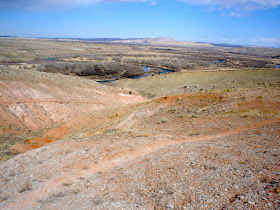
Continuing from the location pictured in my last blog post, we continue the hike toward the hills in the distance.
Since my wife and I aren't mountain climbers, we are glad to find that most hikes to the top are made possible by looking for the paths the animals take. Furthermore, while one side of the hill or mountain looks intimidating, there usually is another side with a manageable slope.


 In the background of the photograph below is Roundtop Mountain.


 In the background of the photograph below is Roundtop Mountain.


 looking northwest (below)
 The shot above looks southwest and the one below looks north from the top of the hill.
 Below is looking east, about half way down the north slope.
 looking northeast (below)
 The above two shots were taken from the location below.
 This dirt road (below) leads back to River Road which follows the Bighorn River on the east side. Directly on the other side of the road is the parking lot for the public access to the river.
We then walked south along the road and passed this sign (looking north).


No comments:
Post a Comment