This is the view of Roundtop from the top of T-Hill. In the foreground is the airport landing strip, and behind that on the left is the cemetery and the golf course on the right.
 To get to the base of Roundtop, go north on 7th Street and continue up the hill (at this point it becomes Airport Road). Just before the cemetery, take a sharp left curve onto Roundtop Drive, and follow the gravel road over the cattle guard and on up the hill. Here is a satellite view of the directions.
 Park at the historical marker below, and begin your hike off to the right toward the bush seen in the photograph below. The marker states, "LEWIS FREUDENTHAL PARK. Roundtop Mountain was donated in 1986 to the people of Hot Springs County by the family of Lewis Freudenthal, to be preserved in its natural state in his memory."
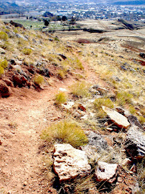
 The path begins easy enough, but it progressively becomes more challenging. The Visitor Center brochure categorizes this climb as "C-Challenging: Difficult. Climbing over rock ledges possible." Shoes with a good tread for traction is a must. The paths next to the steep edge of the mountain are sometimes a foot wide at the most and gravely.

 The daschound in the upper right hand corner below and the car in the distance gives some perspective on the nature of the climb.
 The upper fourth requires some maneuvering around rocks, and the path isn't always obvious. I suggest you study this last portion so that you know where you are going on the descent (we got ourselves confused).
 We are anything but experienced climbers, but we were able to handle the ascent okay. Going down caused us both to feel anxiety as we found our way past the uppermost rocks and ledges and then walked along the path looking down the steep sides. I am embarrassed to report that for a portion of the way I decided to sit on my behind and scoot my way down.
link: index to photographs


No comments:
Post a Comment