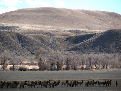
Just before Lower Sunshine Reservoir, we turned off of WY-290 and soon encountered a big herd of elk. This picture below only shows a small portion of it.
 We continued on up Wood River Road and stopped at a ranch which was fattening up some buffalo.
 We continued on up Wood River Road and stopped at a ranch which was fattening up some buffalo.


 Finally we arrived at Shoshone National Forest.
 We wanted to see if we could get to Kirwin, an old ghost town where Amelia Earhart was planning to build a cabin when she disappeared.


 We had another seven miles to get to Kirwin, but with Grandma on board, we thought we had gone far enough when we saw this portion of the road with a stream intersecting it.
 On the way back, we stopped at one of the campgrounds.
 We used the well maintained outhouse on the right.
 Click on the photograph below to read the posters.
 This stream is next to the campground.
 Here are a couple of shots I took after leaving Shoshone National Forest.
 We saw the elk herd once again, but this time they were trying to jump two fences and cross the road. The oil derricks in the background are a common sight in Wyoming.
 About three fourths of the herd made it across the road when we were startled to hear a large boom. Hunters were hiding in the brush and trees. They didn't seem to be successful, however, but the remainder of the herd was cut off from the rest, as the photograph below shows.
 The following three photographs were taken along WY-290 on our way back to Meeteetse.

 This final shot was taken along WY-120 during our drive back home to Thermopolis.


